Operations
Overview
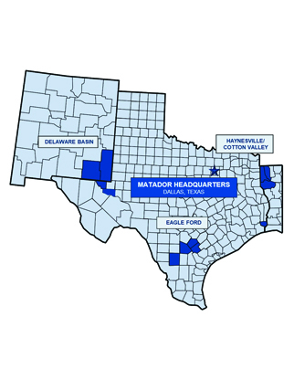
Matador Resources Company’s focus is to create a risk balanced portfolio of exploration opportunities for oil and natural gas in unconventional resource plays, supplemented with exploration for more conventional targets. We concentrate our exploration efforts primarily on known hydrocarbon-producing areas with well-established production histories offering the potential for multiple-zone completions. Our current operations are focused primarily on the oil and liquids-rich portion of the Wolfcamp and Bone Spring plays in the Delaware Basin in Southeast New Mexico and West Texas. We also operate in the Eagle Ford shale play in South Texas and the Haynesville shale and Cotton Valley plays in Northwest Louisiana.
Our principal areas of operation consist of:
- Southeast New Mexico and West Texas – Delaware Basin
- South Texas – Eagle Ford shale and other formations
- Northwest Louisiana – Haynesville shale, Cotton Valley and and other formations
Southeast New Mexico and West Texas
DELAWARE BASIN
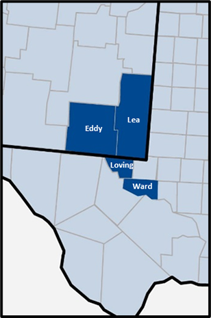
The greater Permian Basin in Southeast New Mexico and West Texas is a mature exploration and production region with extensive developments in a wide variety of petroleum systems resulting in stacked target horizons in many areas. Historically, the majority of development in this basin has focused on relatively conventional reservoir targets, but the combination of advanced formation evaluation, 3-D seismic technology, horizontal drilling and hydraulic fracturing technology is enhancing the development potential of this basin, particularly in the organic rich shales, or source rocks, of the Wolfcamp formation and in the low permeability sand and carbonate reservoirs of the Bone Spring, Avalon and Delaware formations.
In the western part of the Permian Basin, also known as the Delaware Basin, the Lower Permian age Bone Spring (also called the Leonardian) and Wolfcamp formations are several thousand feet thick and contain stacked layers of shales, sandstones, limestones and dolomites. These intervals represent a complex and dynamic submarine depositional system that also includes organic rich shales that are the source rocks for oil and natural gas produced in the basin. Historically, production has come from conventional reservoirs; however, we and other industry players have realized that the source rocks also have sufficient porosity and permeability to be commercial reservoirs. In addition, the source rocks are interbedded with reservoir layers that have filled with hydrocarbons, both of which can produce significant volumes of oil and natural gas when connected by horizontal wellbores with multi-stage hydraulic fracture treatments. Particularly in the Delaware Basin, there are multiple horizontal targets in a given area that exist within the several thousand feet of hydrocarbon bearing layers that make up the Bone Spring and Wolfcamp plays. Multiple horizontal drilling and completion targets are being identified and targeted by companies, including us, throughout the vertical section, including the Brushy Canyon, Avalon, Bone Spring (First, Second and Third Sand) and several intervals within the Wolfcamp shale, often identified as Wolfcamp A through D.
South Texas
EAGLE FORD SHALE AND OTHER FORMATIONS
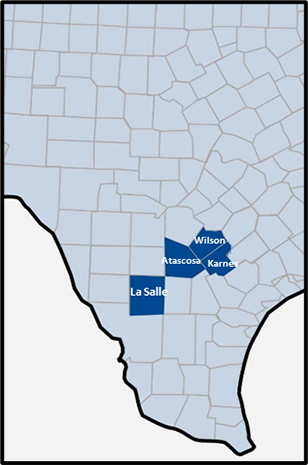
The Eagle Ford shale extends across portions of South Texas from the Mexican border into East Texas forming a band roughly 50 to 100 miles wide and 400 miles long. The Eagle Ford is an organically rich calcareous shale and lies between the deeper Buda limestone and the shallower Austin Chalk formation. Along the entire length of the Eagle Ford trend, the structural dip of the formation is consistently down to the south with relatively few, modestly sized structural perturbations. As a result, depth of burial increases consistently southwards along with the thermal maturity of the formation. Where the Eagle Ford is shallow, it is less thermally mature and therefore more oil prone, and as it gets deeper and becomes more thermally mature, the Eagle Ford is more natural gas prone. The transition between being more oil prone and more natural gas prone includes an interval that typically produces liquids-rich natural gas with condensate.
Most of the current Eagle Ford shale activity is concentrated in Atascosa, Bee, DeWitt, Dimmit, Frio, Gonzales, Karnes, La Salle, Lavaca, Live Oak, Maverick, McMullen, Webb, Wilson and Zavala Counties in South Texas. The first horizontal wells drilled specifically for the Eagle Ford shale were drilled in 2008, leading to a discovery in La Salle County. Since then, the play has expanded significantly across a large portion of South Texas. We believe the majority of our Eagle Ford acreage is prospective predominantly for oil or liquids-rich natural gas with condensate. In addition, we believe portions of this acreage may also be prospective for other targets, such as the Austin Chalk, Buda, Edwards and Pearsall formations, from which we would expect to produce predominantly oil and liquids.
Northwest Louisiana
HAYNESVILLE SHALE, COTTON VALLEY AND OTHER FORMATIONS
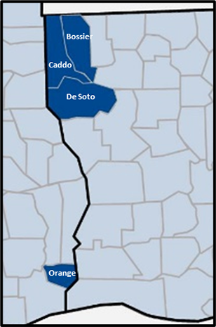
The Haynesville shale is an organically rich, overpressured marine shale found below the Cotton Valley and Bossier formations and above the Smackover formation at depths ranging from 10,500 to 13,500 feet across a broad region throughout Northwest Louisiana, including principally Bossier, Caddo, DeSoto and Red River Parishes in Louisiana. The Haynesville shale produces primarily dry natural gas with almost no associated liquids. The Bossier shale is overpressured and is often divided into lower, middle and upper units. The Cotton Valley formation is a low permeability natural gas sand that ranges in thickness from 200 to 300 feet and has porosity ranging from 6% to 10%.